Östergarnsholm
In 1995 the Östergarnsholm field station was established on a small island located 2 nautical miles off the east coast of Gotland with an instrumented 30 m tower used for many types of atmospheric micrometeorological research and studies of atmosphere-wave-sea interactions and gas exchange. Since 2015 it is part of the European Research Infrastructure ICOS (Integrated Carbon Observation System) to quantify and understand the greenhouse gas balance of the European continent and of adjacent regions.
Infrastruktur
ICOS Östergarnsholm welcomes individual researchers and research groups to come to our measurement site and use existing infrastructure for their own measurements and collaborations. Regardless if it is a research visit with placement of equipment on our measurement tower, hut or in the form of ship-based measurements passing by our site we welcome you and will do our best to accommodate your needs.
Östergarnsholm is a remote island reachable by boat from Gotland run by local citizen on contract with Uppsala University. The site is usually visited about every second month for maintenance if weather and sea conditions are permitting this. The buoy sensors are typically exchanged twice per year with factory calibrated instruments. There is no ice cover on the site, however the harbor in Herrvik on the east coast of Gotland, where the boat is starting from, can freeze in the wintertime making the site seasonally difficult to access. The typical annual atmospheric temperature range is from -20oC to +20oC on the site.
There is no grid power on Östergarnsholm but the site has its own power supply consisting of wind turbines, solar panels and a backup diesel generator owned by Uppsala University and monitored by an external company. It is an autonomous system delivering 12 V, 24 V and 230 V. The total electricity capacity available on the site is about 2.5kW (in operation since November 2016). The diesel generator is placed approximately 400 m north from the measurement tower (close to the old harbor) to minimize influence on the measurements.
There is a small unheated measurement hut shared by Uppsala University, Stockholm University and visitors with an available space of approximately 6.5 m2. For temporary storage there is also some limited space inside a stainless-steel shipping container used for a large battery bank as part of the power supply system. There is data connection in the form of 3G modem on the site. There is no motor vehicles on the island. There is a cart to pull equipment from the harbor to the site.
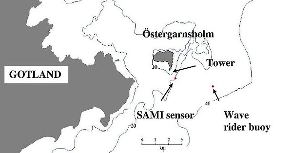
Mätstationen ligger cirka 4 km från Gotlands ostkust på Östergarnsholm vilket är en liten, relativt plan ö med en utbredning på cirka 2 km i väst-östlig och nord-sydlig riktning. Maxdjupet på havet inom en kilometers radie är cirka 30 m.
%20(2)%20Figur5_boat.jpg)
%20(2)%20Figur6_Elkraftsgenerator.JPG)
%20(2)%20Figur7_M%C3%A4tbod_och_str%C3%B6mf%C3%B6rs%C3%B6rjning.JPG)
Mätningar
Atmospheric measurements on the site includes 3D wind speed with sonic anemometers, eddy covariance measurements of CO2, H20 and heat fluxes. There is a gradient system for CO2 and H20 at the site and propeller anemometers and thermocouples in the 30 m tower. Relative humidity, atmospheric pressure, global radiation and precipitation is also measured on the site. During different time periods other parameters have also been observed such as methane, oxygen and clouds.
Water-side measurements are taken using several different sensors semi-continously during active deployment periods. These measurements include sea surface temperature and profile measurements of temperature and conductivity (measured as proxy for salinity) at depth ranging from about 0.5 to 20 m. Also measured are carbon dioxide (pCO2), oxygen, pH, Chlorophyll, Turbidity and fDOM as well as wave parameters in collaboration with Finnish Meteorological Institute (FMI). Discrete manual water side measurements and sampling include Phosphorous (TP, PO4), Nitrogen (TNm, NH4, NO3+NO2) and Silica (DSi).
%20Figur1_mast.JPG)
Foto från 30 m tornets bas. Sensorer på olika tidsperioder har bytts ut och bytt plats mellan olika höjder.
Klimat
With a mean annual air temperature of 7°C and a mean annual precipitation of 383 mm (data period 1961-1990, SMHI station Östergarnsholm) the climate is characterized after Köppen as a Cfb-climate, i.e. humid temperate with mild summers and mild winters.
The cold water in spring and summer gives dominantly stable atmospheric stratification during April to July. Despite low winter temperatures, the sea surrounding Östergarnsholm has ice free conditions throughout the year. Higher rates of cyclonic activity in winter result generally in higher wind speeds in winter than in summer.
The island is small and flat covered by small rocks and pebbles. The vegetation on the island consists of a few single trees (mainly in the N-E corner) as well as low herbs and grass together with small bushes.
The carbon cycle represented by the Östergarnsholm site shows a strong seasonal variation with marine carbon uptake from April to October, and emissions from November to March. Algae blooms with resulting biofouling on water-side sensor is fairly common in summer time.
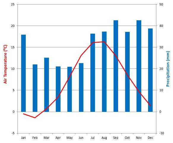
Klimatdiagram för Östergarnsholm (1961-1990, SMHI station Östergarnsholm). Diagrammet visar månadsmedelvärden för temperatur och nederbörd. När nederbördsstaplarna är nedanför temperaturkurvan indikeras en torrsäsong. När nederbördsstaplarna når över temperaturkurvan indikerad ett fuktigt klimat.
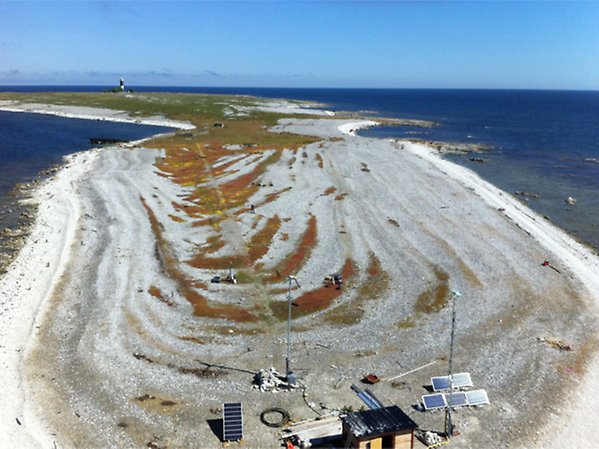
Foto över Östergarnsholms vegetation och delar av sitens infrastruktur. Fotot är taget innnan tillkomsten av uppdaterad strömförsörjningslösning (November 2016).