Infrastructure
In this section, the Norse World infrastructure or system is described. The Norse World infrastructure consists of four components: a database, a REST-API, an admin-user interface, and an interactive end-user interface (Figure 1). The system is loosely coupled, i.e. designed in such a way that each component is independent and can be further developed, scaled and/or updated without affecting the rest of the system. All of the components use well-known, open-source frameworks and programming languages accessible to a wide majority of amateur and professional developers allowing them to understand the code and further develop the resource. The Norse World infrastructure is released as open source allowing further development by third parties; for details, see 'Terms of use'.
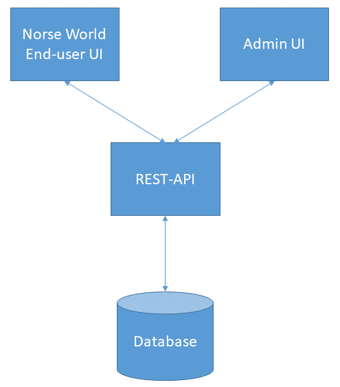
Figure 1. The Norse World system overview. UI stands for user interface.
Database
The core of the system is a bespoke back-end MySQL database containing the data. For details about the data, see 'Data and metadata'.
REST-API
The REST-API web application reads and writes data to and from the database. In other words, it is a separate back-end application that allows admin users e.g. to enter new data, while end-users are able to access the database when making queries through the Norse World end-user interface. The REST-API uses JSON as its open standard format and is compatible with both GeoJSON and JSON-LD. Furthermore, the API fits seamlessly in with major offline open-source GIS applications such as QGIS. For further details and to access the REST-API, see 'REST-API'.
Admin-user interface
The admin-user interface is a web application that allows admin-users to work with and administrate the data stored in the system. The application uses the REST-API's read/write.access to the database to view and/or add/update the data.
Norse World end-user interface
The Norse World end-user interface is an interactive map resource based on the Leaflet library that allows end-users to access the system and make queries in the database. The web application reads data via the REST-API and then plots them on the map. The end-user interface is reached by www.uu.se/norseworld/map.
The system documentation and other additional information, such as 'Terms of use' and 'How to use Norse World', is gathered on a separate webpage, www.uu.se/norseworld.