CASE Study area: Peloponnesos
About the project study area
The Peloponnesian peninsula extends over a surface of 21 400 km2 (slightly smaller than Sicily or Sardinia) with a topography that varies greatly over short distances. Large areas of the peninsula are high-altitude and mountainous and only narrow and elongated areas of lowland exist, mainly along the 1000 km long coastline. Today, the population is relatively equally distributed avross the peninsula, with slight emphasis on the northern and north-western regions. In contrast, these regions are the least well-known from an historical and prehistorical perspective.
Why the Peloponnese?
- It is a well delimited geographical region,
- of a size well suitable for regional modeling.
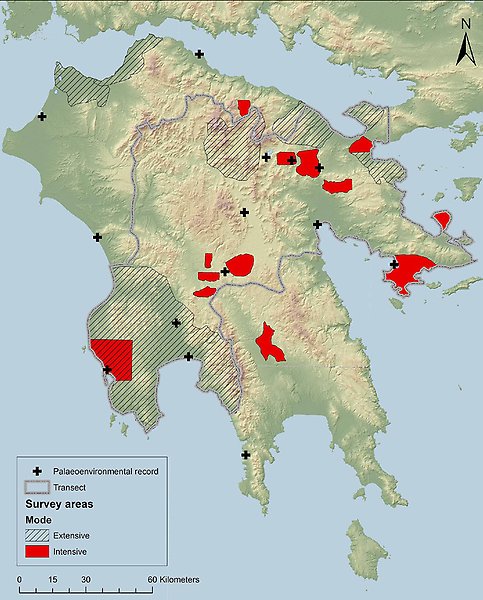
- Many archaeological field survey project has been conducted in the region since the 1960's, with well published material on settlement patterns (see the map above: red areas mark intensive surveys, while striped areas show extensively surveyed areas).
- The region is well represented in historical sources.
- Comprehensive coverage in terms of scholarly research into the archaeological and historical particulars of the region.
- An increased number of high-resolution climate and environmental records have been made available during the last five years - data derived from caves and wetlands - a development within which CASE takes active part (the + on the map show the locations of the paleoenvrionmental archives).
- The research station Navarino Environmental Observatory (NEO) is a unique resource for study visits to the area and crucial for many Swedish projects in the region.
- The region encompass many topographical, climatological and ecological niches, from the well-watered plains in the south-west, over the marginal mountain regions in central Peloponnese, to the more arid cosatal regions in the north-west and the in all periods politically and economically important Argive Plain.
- The region is a geographical interface between the Eastern Mediterranean/Aegean and the Adriatic-Ionian contact networks, of importance throughout history.
- Its distance from the historical core of the Greek Mainland – Attica/Athens – has rendered it a somewhat ambiguous position within the core-periphery spectrum, with high chronological variability, in an Aegean and intra-Peloponnesian perspective.