Project overview
The Norse Perception of the World: A mapping and analysis of foreign place names in medieval swedish and danish texts
Fornnordisk omvärldsuppfattning: En kartering och analys av utländska ortnamn i svenska och danska texter från medeltiden.
The Norse Perception of the World project is funded by the Swedish Foundation for Humanities and Social Sciences, Riksbankens Jubileumsfond, (2017–2020) to create an online, searchable index of foreign place names and other spatial references in medieval Swedish and Danish texts with mapping capabilities.
National Library of Sweden, MS M 306
East Norse (Old Swedish and Old Danish) literature is a mine of information on how foreign lands were visualised in the Middle Ages: What places were written about and where? Are some places more popular in certain text types or at certain times? How do place names link different texts? Is there a shared concept of spatiality? How is space gendered?
Definitions of East Norse (Old Swedish and Old Danish)
Spatial humanities, the spatialisation of literary studies, and cognitive mapping are growing fields within digital humanities, but the study of spatial thinking and knowledge in medieval Scandinavia and its development as an area of enquiry are hampered by a dearth of information on place names in literary texts. Any research aiming to uncover what pre-modern Scandinavians understood about places abroad requires as a minimum an index of foreign place names in East Norse literature, an infrastructure that has not existed until now.
The structure of the project overview is as follows:
- Aim and purpose
- Material
- Theoretical considerations
- Critical visualisation
- Links to lists of sources, genres etc. and 'References'.
Aim and purpose
The overall aim of the project is to create an infrastructure in the form of an online, open access searchable index and mapping of the foreign place names found in medieval East Norse texts. This is accomplished by a bespoke back-end MySQL database containing the data (i.e. the index), Norse World, an interactive search and mapping resource based on the Leaflet library, and a REST-API, a separate back-end application that allows end-users to access the database when making queries through the map resource and an admin interface for data input (read more under 'Infrastructure'). The REST-API uses JSON as its open standard format and is compatible with both GeoJSON and JSON-LD. Furthermore, the interface fits seamlessly in with major offline open-source GIS applications such as QGIS. All of the mentioned components use well-known, open-source frameworks and programming languages accessible to a wide majority of amateur and professional developers allowing them to understand the code and further develop the resource.
The data are extracted from a large corpus of fictional, non-biblical medieval texts from medieval runic inscriptions, manuscripts, early prints (before 1515), such as romances, travel stories, pilgrim guides, saints’ lives, devotional literature, revelations, prayers, didactic works, and sermons as well as encyclopaedic works (see 'Material'). Some of these texts exist in editions of varying quality while others are as yet unedited and housed in different archives and libraries in Scandinavia and abroad. The project is thus collecting data that are scattered and otherwise difficult to access, and sorting and presenting them in a uniform manner. The index is completely new, the first of its kind, and not just a repackaging of pre-existing material. The data can also be plotted onto interactive digital maps that enables researchers to visualise what Swedes and Danes wrote about foreign lands in the Middle Ages and by using search filters analyse how this interest and focus was constructed and shifted across time and literary genre. The data are be freely accessible to scholars and other interested parties around the world and can also be downloaded as a CSV-file, usable in for instance Microsoft Excel or offline GIS applications as QGIS. See also 'How to use Norse World'.
The project’s result will be of use to researchers in the fields of onomastics, medieval literature, philology, history, geography, archaeology, theology, and linguistics. Additionally, it is cementing the study of spatial thinking and knowledge in medieval Sweden and Denmark as an interdisciplinary research field in Scandinavia.
Material
The material from which the the data of foreign place names is extracted consists of literary texts in the Swedish and Danish vernacular languages. Described below are the definitions and restrictions we pose on the material.
Dating
What is considered ‘medieval’ can differ from country to country or even between fields of inquiry. For the purposes of this project, medieval is considered to be when Old Danish and Old Swedish were used. The traditional datings for the periodisation of Old Danish and Old Swedish, ending with the first Bible translations, are not the same: Danish New Testament 1524, Swedish New Testament 1526. For our purposes, we have harmonised the cut-off point for texts in either language to 1515 (which is also the cut-off year for Gammeldansk Ordbog).
If a medieval text only exists in a copy made after 1515, as for example is the case with Historia Trojana (Geete 1892), then we move the cut-off year to 1530. In this way, we will be able to include medieval texts composed before 1515, but that only survive in copies from just a few years later.
Vernacular language
Although Latin was the dominant international language and the channel through which new ideas and concepts came to Scandinavia, the vernacular languages, Old Danish and Old Swedish (East Norse), were the communication channels through which popular education reached both the literate and – through preaching and drama – the illiterate audience, and through which the vast Latin literary matrix was conveyed to the laity. Vernacular works were usually aimed at a broader audience than just those able to read and understand Latin, and therefore they better demonstrate the widespread knowledge, attitudes, beliefs, and assumptions that cut across society than do the authoritative writings in Latin of the religious establishment. As the principal source of entertainment and instruction, vernacular texts provide us with an opportunity to investigate the medievals’ knowledge about the world abroad.
In some vernacular texts, foreign place names (as well as exotic objects, such as gems and minerals) can appear in a Latinised form (often reflecting the form in the original Latin text; see Adams 2010, 131n21). For our purposes, if a place name occurs in a vernacular context, it is included in the database.
Sources
The material comprises parchment and paper manuscripts and fragments, early printed books, and medieval runic inscriptions (of which there are just three written in the vernacular [Old Swedish] that mention foreign place names: Vg 81; Vs 14; G 126). Here is a complete list of our sources:
List of sources (pdf) Pdf, 270 kB.
Genres
Medieval East Norse literature covers a wide range of genres. In order to create the database and provide a tool for researchers to investigate the perception of the world in Old Danish and Old Swedish texts, we are incorporating the following genres of fictional and encyclopaedic works (see also our list of texts sorted by genre).
Religious works
These include: devotional works, such as legends (the Old Swedish material – Fornsvenska legendariet – is particularly rich here), miracles (often found in exempla in sermons), prayers; dreams, visions, and revelations (dominated by the figure of St Birgitta); poems; didactic works such as drama, sermons, and pilgrim guides (of which there is just one, in Old Danish).
The contents of some of these works (such as legends, miracles, sermons, and prayers) would have been familiar even to the illiterate population, who would have been told the stories during sermons and instruction in church.
Secular works
These include romances (Eufemiavisorna and ridderromanerne); encyclopaedic and didactic works, such as proverb collections (particularly Peder Laale); chronicles and histories, and travel tales.
Some of these works (chronicles, travel tales, encyclopaedic works) would have been less familiar to the majority of the population, and restricted to more learned or wealthy circles. The encyclopaedic works, such as Sydrak and Lucidarius (Knudsen 1921–1932; Frederiksen, Bersagel and Skog 2008), are of particular interest as they typically aimed at describing and explaining the world.
Excluded material
The following material has been excluded from the project:
a) Diplomas and charters: It is impossible at this stage to go through the entire corpus. In Sweden alone, there are over 40,000 extant diplomas (principally in Latin, Old Swedish, Middle Low German). The onomastic information to be drawn from the material mainly mentions domestic place names or expected foreign places, e.g. Paris, Rome, Lübeck, that add little to our knowledge of the perception of the world. Furthermore, this onomastic material is usually published as indexes, making the need for its inclusion in the database less pressing.
b) Law texts: There are very few place names at all mentioned in these texts, and foreign place names are largely non-existent.
c) Biblical texts: The place-name material in the Bible (and the East Norse translations and paraphrases) is well-known and does not demonstrate a specifically Scandinavian view of the world.
d) Viking-Age runic inscriptions: Although these do contain examples of place names in a vernacular context, they are not from the medieval cultural situation. Furthermore, they have already been indexed in Peterson 2007: 309–25.
Place name
Place names are names of topographical, physical and cultural features and constitute the largest group of the project's spatial referents. Examples are France, Mount Sinai and Basilica of Saint John Lateran. For more information, see 'Data and related metadata: spatial references and spatial data'.
Data and related metadata: spatial references and spatial data
Non-name
Non-names is a collective term for spatial references that are not covered by the category place names. The category is heterogenous and comprises adjectives, adverbs, coin designations, inhabitant designations, language designations, noun bynames, and origin designations. For more information, see 'Data and related metadata: spatial references and spatial data'.
Data and related metadata: spatial references and spatial data
Theoretical considerations
Below we present the theoretical background to choices the project has made in the conceptualisation and methodology of the project:
- Foreign and “utlændsker”
- The concept of space
- Editions vs. primary sources
- Reusing existing infrastructures.
Foreign and “utlændsker”
In many ways, the concept of “foreign” (as opposed to “domestic”) was different in the Middle Ages from today (see, for example, Connell 2015). Whereas the term in modern parlance usually applies to other countries abroad, the medievals used words such as “utlændsker” or “fræmadha” to refer both to places abroad in other countries and to places in other regions within the realm. For example, in a Swedish diploma from 2 October 1413 (SDHK-nr: 18106), we read: “Pædhar i Medhinghe hafdhe borth salth ij øris landh iordh […] enom wthlandzkom man ok ooskyllom, som heth Lasse Pædherson i Wllasæthrom, fore xij marker” (Peter in Medinge had sold two “øre” of land to an “utlændsker” and blameless man, who is called Lars Petersson of Ullersätter(?) for twelves marks). Here we are not to understand that Ullersätter is a foreign place name, but rather that it simply lies in another district.
Knowledge about places abroad – and the associated sense of foreignness – was also structured differently in the Middle Ages. Whereas geographically closer areas such as Sápmi were often described in exotic, foreign terms (Aalto 2010; Bandlien 2015), more distant biblical places would have felt more familiar and domestic through regular preaching, drama performances, and public art (where the “foreign” biblical characters were usually dressed in contemporary, local garb). Thus what a medieval understood as “utlændsker” does not necessarily tally with our modern-day understanding of “foreign”.
For the purposes of our project, we are disregarding medieval understandings of “utlændsker” and simply defining “foreign place names” as referring to localities beyond the current, political borders of Sweden and Denmark. This is not without consequences as it means that regions such as the Swedish parts of Sápmi are not considered foreign, whereas areas in Swedish-speaking Finland or Danish-speaking Southern Schleswig are. However, the shifting borders of medieval Scandinavia coupled with the fluidity of concepts of “‘utlændsker’-ness” make this definition of “foreign place names” the clearest and most categorical to work with.
Moreover, this difference between where the writers and/or readers of the medieval texts imagined that the places mentioned in them were located and where modern-day readers like ourselves locate these places means that we cannot always guarantee that our identification is absolutely correct. Medieval understanding of and ideas about geography were quite different to our own. The issue has, for example, been discussed with the example of maps in Scandinavian manuscripts by Dale Kedwards (Syddansk Universitet) in “Writing geography in Medieval Icelandic Manuscripts: The Case of AM 736 I 4o” at the conference “There and back Again: Writing Spaces, Mapping Places in the Medieval World” (Queens College Oxford, June 2012). Nonetheless, unless there is any information to suggest another location is intended, we shall be using modern coordinates as markers for the place names mentioned in the medieval texts. Read more about gazetteers used here.
The concept of space
This section is mainly taken from Petrulevich, Backman & Adams (2019), see References.
The concept of space varies historically, culturally, and socially (cf. Harrison 1996: 1–2). A number of studies have been carried out to show in what way modern societies perceive space by observing how space is organized or structured (e.g. using cognitive maps, cf. Orleans 1973; Tuan 1974: 33–44; Matei, Ball-Rokeach & Linchuan Qiu 2001) or how it is embedded into the surrounding discourse by interviewing or surveying informants (cf. Mondschein, Blumenberg & Taylor 2010). Working on the conceptualisation and visualisation of spatial thinking in the Middle Ages researchers are bound to insufficient and limited data such as contextualised evidence of place names provided by maps, literature of a variety of genres, diplomas, charters, or any other type of material (cf. the empirical part of Harrison 1996). For medieval Scandinavia, the study of space is still in its infancy (Harrison 1996: [iii]), and although there are studies of local concepts of space and community, “microspatial knowledge” (Harrison 1996; some articles in Davies, Hallsall & Reynolds 2006), there are as of yet no studies of what Danes and Swedes knew and wrote about foreign lands, “macrospatial knowledge” (touched upon in Adams 2015).
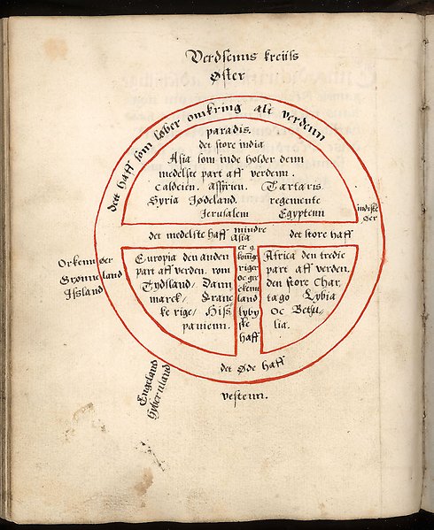
The project follows Harrison (1996: 2–3) and distinguish between the notions of macrospace and microspace analysing the concept of space as a historical category. The macro-level of space is concerned with the cosmographical dimension of life in the Middle Ages embracing ideas about and perception of the structure and the ‘filling’ of the medieval universe at large. Although not always specifically geographically coded (cf. Harrison 1996: 7) the macrospace includes foreign places outside the empirically experienced world of the medievals. On the micro-level the focus instead lies on the empirical geographical knowledge of pre-modern individuals and groups of individuals. The boundaries between the two levels of conceptualisation of space are somewhat fuzzy since they are interlinked in a number of ways. Investigations into microspace are bound to be carried out within the frame of macrospatial thinking, while certain macrospatial ideas seem to incorporate (geographically speaking) microspatial features. For instance, depictions of the city plan of the medieval world centre, Jerusalem, that includes some of its urban toponymy can be placed next to world maps in the Scandinavian medieval manuscript tradition (cf. Kedwards 2014: 41, 81–83).
Previous research has almost exclusively viewed medieval world maps or mappae mundi as contemporaneous visualisations of medieval macrospace (Harvey 1987: 284; Simek 1990:105, 146; Harrison 1996: 4–5). In Scandinavian manuscripts, medieval maps of this kind are very rare. As far as we are currently aware, the East Norse material includes only one such map found in a post-medieval manuscript of the Travels of Sir John Mandeville, Holm. M 306 dated to 1584 (Toldberg 1966: cols 309–311). Thus, this way of picturing the world is perhaps non-applicable to the area of investigation. Moreover, recent scholarship has come to question the assumption above. Studies of world maps as a part of medieval manuscript culture reveal that they are reproduced under “Geometry”, a category that embraced knowledge about the proportions of the world and place names (Kedwards 2014: 17 and works cited therein; cf. Rouse 2014 and works cited therein). The cosmographical, macrospatial dimensions of mappae mundi perceived as such by their users in the past can be challenged as at least partly anachronistic.
Moreover, we argue that the notion of space in the Middle Ages is to be abstracted from medieval textual material, rather than medieval visualisations. There are reasons to believe that geographical and spatial knowledge of the time was textually rather than visually coded (Rouse 2014: 18–19, 26). Medieval literature thus contains written rather that drawn maps allowing protagonists to move in a linear fashion from one place to another. The conveyed spatial data constitutes an inseparable part of a medieval text, since the text binds together spatial and geographical information at the same time as place names and other location-based material link different parts of the text, or different texts.
In the Norse Perception of the World project the macrospatial idea of space serves as its overall frame. The project’s material includes devotional works, such as legends, miracles (often found in exempla in sermons), prayers; dreams, visions, and revelations (dominated by the figure of St Birgitta); poems; didactic works such as drama, sermons, and pilgrim guides. The contents of some of these works (such as legends, miracles, sermons and prayers) would have been familiar even to the illiterate population, who would have been told the stories during sermons and instruction in church. Furthermore, we excerpt data from romances; encyclopaedic and didactic works; chronicles and histories, and travel tales. Some of these works (chronicles, travel tales, encyclopaedic works) would have been less familiar to the majority of the population, and probably restricted to more learned or wealthy circles although their content and the worldview that they reflected was most likely more widely known. The encyclopaedic works, such as Sydrak and Lucidarius (Knudsen 1921–1932; Frederiksen, Bergsagel & Skog 2008), are of particular interest as they are typically aimed at describing and explaining the world.
Editions vs. primary sources
We are mainly using published paper editions of Old Danish and Old Swedish texts, the vast majority of which have no indexes, making searching and excerpting difficult. Old Danish texts have been edited and published by several different societies, such as Samfund til Udgivelse af Gammel Nordisk Litteratur (STUAGNL) and Universitets-Jubilæets danske Samfund. Several in-house editions made by Gammeldansk Ordbog at the Society for Old Danish and Literature are also available to us. The principal edition series for Old Swedish that we are using is Svenska fornskriftsällskapets samlingar.
Fortunately, there is a long tradition of diplomatic editing in East Norse philology and many editions are transcribed in a suitable manner. However, older editions can be problematic, particularly in the use of capitalisations, (silent) editorial amendments, and punctuation. Each edition is therefore assessed for suitability as sources, and manuscripts are consulted to check readings in those instances where the edition is deemed too poor and the manuscript (or early print) is readily available. The difficulties of using primary sources in Sweden and Denmark, due to few manuscripts or early printed books having been digitised and being freely available, prohibits them from being our main source of data. Since the Swedish and Danish corpus is quite limited, the diplomatic, critical editions in most cases provide all place name variants in the critical apparatus. The corpus comprises nearly 200 manuscripts, books and inscriptions in East Norse (see a list of Sources).
List of sources (pdf) Pdf, 270 kB.
Despite recent developments in digital text editing, there is a significant shortage of texts available in scholarly, digital editions and there are just a few electronic texts at our disposal:
a) Middelaldertekster provides by far the most extensive collection of Old Danish manuscripts available in scholarly, accurate, digital editions (Hjort 2005; Jørgensen 2006: 91–93; Nielsen 2015). It includes 15 of the Old Danish manuscripts used on the project: AM 28, 8; Holm. B 77; Holm. C 67; Holm. D 600; Holm. K 47; Holm. K 48; NkS 606, 8; NkS 66, 8; NkS 70R, 8; NkS 813x, 4; Thott 585, 8, and the early prints: Jærtegnspostillen, Jesu Barndomsbog, Jon Præst, and Tyrkens Tog til Rhodos.
b) Fornsvenska textbanken comprises older editions from the Svenska fornskriftsällskapet series which have either been typed in manually or scanned. The accuracy of the transcriptions is compromised by letter-recognition errors and the failure to mark abbreviations, and the quality of the database is consequently not good (Williams 2010: 226ff). The text-bank includes a number of transcriptions of parts of the Old Swedish manuscripts that we shall be consulting on the project, but will only be used sparingly and with care.
c) Menota has developed detailed encoding standards for publishing medieval Nordic texts, but to date there are just thirty-two texts available, the vast majority in Old Icelandic or Old Norwegian. Although there are no Old Danish texts, there are four Old Swedish manuscripts in facsimile transcriptions (Holm. A 10, A 49, A 80, D4) which we shall be excerpting (and converting forms to diplomatic transcription).
d) Ingela Hedström (Riksarkivet, Stockholm) is making her private corpus of electronic editions of Old Swedish prayer books available to us (including Holm. A 36, A 37, A 38, A 43, A 80, A 81, A 82, A 82a). Furthermore, Adams and Backman have several electronic editions of Old Danish and Old Swedish manuscripts, including AM 792, 4o and Holm. D 3.
Reusing existing infrastructures
We reuse information from already existing databases and infrastructures and provide links to the sites in question. For information on edition, electronic edition or other secondary information we use Libris, Tekster fra Danmarks middelalder og renæssance 1100-1550 - på dansk og latin or Fornsvenska textbanken.
- Libris
- Tekster fra Danmarks middelalder og renæssance 1100-1550 - på dansk og latin
- Fornsvenska textbanken
For information on source descriptions, digitised sources or bibliographical details we use:
Critical visualisation
The text in this section is taken from Petrulevich, Backman & Adams (2019), see 'References'.
Paradox of representation and conceptual anachronism
To visualise place names and non-name spatial references on a map they need to be geocoded, i.e. assigned coordinates. The geocoding procedure implies a transposition of the modern concept of space taken from hard sciences into research mainly preoccupied with the past, which almost automatically leads to conceptual anachronism. Within the field of history conceptual anachronism is defined as a “corruption of the use of modern concepts in historical narratives” (Poe 1996: 352; cf. Fairburn 1999: 203–204.). Anachronisms of this kind violate one of the key principles of the historical scholarship, that of discontinuity which postulates the inherent difference between the past and present (Poe 1996: 347–348). As Marshall Poe (1996: 349–354) puts it conceptual anachronisms can be seen as research compromises emanating from the so-called paradox of representation. The paradox itself implies a requirement of accurate historical descriptions despite the lack of conceptual links between the past and present. Applying modern concepts in historical research, termed translation by Poe (1996: 350), can be seen as a way of eliminating or resolving the paradox. Conceptual anachronisms can in other words be both “good” and “bad”, while certain types of research, e.g. pattern-searching scholarship based on large datasets, even infer a certain portion of conceptual anachronism. However, there are no clear-cut criteria to distinguish between “sensible compromises” and “heavy-handed corruptions” in the world of conceptual anachronism (Poe 1996: 354–355).
For the Norse Perception of the World project, the compromises involving conceptual anachronism are inescapable, since substantial amounts of attestation data from historical sources are made compatible with GIS standards. Furthermore, the focus lies on frequencies of mentions to facilitate quantitative analyses of collected data. We consider the compromises we made sensible, but it is of crucial importance for the end-user to be aware of the limitations of the Norse World resource, and, more importantly, the choices the project team has made to collect, geocode, and visualise data.
Geospatial visualisation as a method and an analytical tool
The Norse World infrastructure visualises spatial data through interactive clustering, an “upgraded” version of conventional point data mapping (cf. Börner 2015: 52–55). This presentation mode forms a contrast to traditional qualitative analysis of manuscripts and early prints in the field of Scandinavian philology. Shifting the focus from qualitative to quantitative aspects of philological data opens new possibilities to explore the material that did not exist before, reveals patterns that otherwise go unnoticed, and through this changes the way we approach historical spatial information and the world it represents (cf. Foka & Gelfgren 2017: 150 with references). For instance, East Norse multitext manuscripts have rarely been edited as single entities since traditional textual criticism instead favours publishing single works preserved in multiple handwritten sources (with few exceptions, e.g. Frederiksen, Bersagen & Skog 1993–2008; Andersson 2006; Arvidsson’s electronic edition of Holm. D 4 (2016) at Menota). The Norse World platform opens an unprecedented opportunity to access and analyse spatial data fetched from one or more multitext manuscripts. However, thorough contextualisation is needed to clarify why we consider utilising the Leaflet.markercluster plugin as the ultimate visualisation technique for the current project.
The geospatial visualisation employed by the Norse World resource by no means has an ambition to represent a historically correct worldview of medieval Scandinavians. Rather, it serves as a method of managing and getting an overview of large amounts of spatial data. At the same time, the employed clustering technique can be utilised as an analytical tool to facilitate comparisons of data distribution in different types of material. Thinking visually about location-based data irrespective of its origin can be seen as a contemporary norm: complex information is distilled down to a visual argument that can be shaped and defined as the researcher needs (Wrisley 2014).
See also 'The concept of space' in 'Theoretical considerations'.